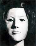
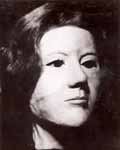
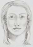
CA SACRAMENTO COUNTY JANE DOE: WF, 18-31, found off I-5 near Sacramento, CA - 27 Oct 1981 - red flower tattoo *LILLY PRENDERGRAST*

1603932495358.png

1602978441853.png

142UFCA - Unidentified Female
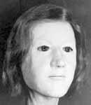
142UFCA.jpg
142UFCA1.jpg
142UFCA2.jpg
142UFCA3.jpg
Sketch of tattoo

Reconstructions of the decedent; sketch of tattoo.

Date of Discovery: October 27, 1981
Location of Discovery: Sacramento County County, California
Estimated Date of Death: 1980-1981
State of Remains: Decomposed
Cause of Death: Unknown

Physical Description
Estimated Age: 18-31 years old
Race: White
Sex: Female
Height: 5'0" to 5'4"
Weight: 100 to 110 lbs.
Hair Color: Brown
Eye Color: Unknown
Distinguishing Marks/Features: There was a tattoo of a red flower with a red stem and two green leaves located on her right hip/buttock area. Congenital defect of a 3/8" hole in one end of her sternum bone. Petite build. Anthropology reports state that she may have had dark skin and been right handed.

Identifiers
Dentals: Available. Her teeth were in good repair. She was determined to be a smoker due to heavy nicotine stains on her teeth. She had four fillings on her bottom teeth only. Her front left incisor overlapped the bicuspid slightly.
Fingerprints: Not available.
DNA: Available.

Clothing & Personal Items
Clothing: Red panties. Clothing and a shoe were found in the vicinity.
Jewelry: Unknown.
Additional Personal Items: A tie tack in the shape of a cocktail glass was found under her.

Circumstances of Discovery
The decedent was located on the west side of Interstate 5, 1.7 miles south of Freeport Boulevard and 2.5 miles south of Pocket Road in Sacramento, California on October 27, 1981.

Investigating Agency(s)
Agency Name: Sacramento County Coroner
Agency Contact Person: Dustin Driscoll
Agency Phone Number: 916-874-9680 or 817-240-4106
Agency E-Mail: coronerweb(at)saccounty.net
Agency Case Number: 81-83761

Agency Name: Sacramento County Sheriff's Department
Agency Contact Person: Christine Kneeland
Agency Phone Number: 916-874-8493 or 916-874-1751
Agency E-Mail: ckneeland(at)sacsheriff.com
Agency Case Number: 811820

NCIC Case Number: U170008704
NamUs Case Number: 2406

Information Source(s)
NamUs
Sacramento County Coroner
 
Last edited by a moderator:
I think it's really unusual that a woman of this age would have stains on her teeth due to nicotine. Unless she didn't brush often? Could she have been a transient?
 
This unidentified woman was found not far from where I live. The exact location is hard to tell from the description.

Freeport blvd runs north and south and Pocket road runs east and west. The location is given as 1.7 miles south of Freeport blvd and 2.5 miles south of Pocket road. That doesn't makes sense to me. How do you find a spot 1.7 miles south on a road that runs north and south? Where's the starting point?

If you go 2.5 miles south of Pocket you would be in Yolo County because the Sacramento River takes a sharp bend there.
Would it be difficult to take a body there, you mean?
 
I'm not sure why the location info is messed up.

I do know the area, in fact back in 1981 I used to drive by that area often. My friends and I would drive down Pocket rd to get to Garcia Bend Park to launch a boat and go water skiing.

At the same time a good friend worked at a restaurant in the small town of Freeport that I would go to which you get to by, that's right, Freeport blvd.

Back then there was a lot of open farm land and not a lot of traffic. I could see someone finding it a good area to leave a body without being detected.
 
This appears to not be accurate at all, but this is where NamUs has it mapped - https://www.google.com/maps/place/3...3m4!1s0x0:0x0!8m2!3d38.5128714!4d-121.4970294

NamUs has been very off in their mapping before. Some LE/ME are more detailed than others. I'm pretty sure it's not at all accurate as the Doe Network description says WEST of I5. But I do see Freeport Blvd and Pocket Rd on the map, so at least there's that.
 

Nameless Since 1981, Detectives ID Woman Whose Remains Were Found On Sacramento Freeway Shoulder​

Decades after the skeletal remains of a woman were found on the shoulder of Interstate 5 in Sacramento, detectives finally have a name.


However, a break in the case came in February. The Sacramento County Sheriff’s Office says they were notified about a match of familial DNA to the remains.


As a result, the woman was finally identified as Lilly Ann Prendergast.

Prendergrast, who was 26 when her remains were found, was reportedly last seen leaving her family’s Dallas, TX home back in late 1980 and also had ties to the Ohio, Florida, Georgia and Texas areas. Detectives say she was known to hitchhike, but it’s unknown how she ended up in Sacramento.

Now, the sheriff’s office is hoping Prendergast’s identification will help jog the memories of anyone with information regarding her disappearance and death. Anyone with information relevant to the case is urged to leave a tip at (916) 874-8477.

1603932393483.png
 
This appears to not be accurate at all, but this is where NamUs has it mapped - https://www.google.com/maps/place/38°30'46.3"N+121°29'49.3"W/@38.5128714,-121.4992181,17z/data=!3m1!4b1!4m5!3m4!1s0x0:0x0!8m2!3d38.5128714!4d-121.4970294

NamUs has been very off in their mapping before. Some LE/ME are more detailed than others. I'm pretty sure it's not at all accurate as the Doe Network description says WEST of I5. But I do see Freeport Blvd and Pocket Rd on the map, so at least there's that.
One thing or the other is wrong because the initial post here says the west side of 5. If north is up on this map then the starred area is east of five... Maybe it is dates things were done and the highways, etc. are different now than in 1981 and where they route or curve...? I know a major route near me used to go through a certain city with one exit and now it is routed around the city with several exits...

Regardless, awesome she is identified. Now if they can determine what happened...
 
Last edited:
One thing or the other is wrong because the initial post here says the west side of 5. If north is up on this map then the starred area is east of five... Maybe it is dates things were done and the highways, etc. are different now than in 1981 and where they route or curve...? I know a major route near me used to go through a certain city with one exit and now it is routed around the city with several exits...

Regardless, awesome she is identified. Now if they can determine what happened...
She sure was a pretty girl.
 

Forum statistics

Threads
3,003
Messages
240,144
Members
962
Latest member
birdalsgal
Back
Top Bottom