DAVID "DAVE" EDWIN LEWIS: Murder & arson 13 miles east of Ashland, OR - 4 September 2008

IMG_4394.jpeg


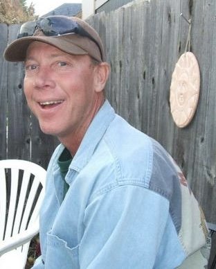
David "Dave" Lewis was a 46 year old father of three. A jack of all trades and good man in any camp, Dave was well known and well respected in his mountain community where he lived on the summit of Dead Indian Memorial Road, 13 miles east of Ashland, Jackson County, Oregon for more than 20 years.

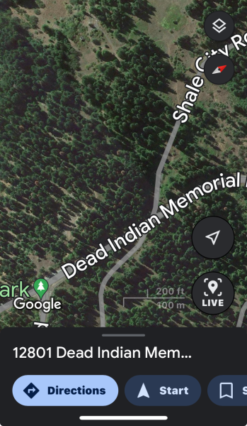
David was found dead after a fire at his rural cabin at 12801 Dead Indian Memorial Road. He had been murdered, shot & the cabin set fire.

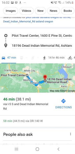
David's remains were identified by DNA. There was also ANOTHER FIRE near Dave's cabin that same night, at a vacant vacation cabin at 18196 Dead Indian Memorial Road, about 5-6 miles away.

Edited to add media link: Dave Lewis was found murdered in his rural cabin east of Ashland, Oregon in 2008. His murder remains UNSOLVED!
 

Attachments

  • DELeagles.jpeg
    DELeagles.jpeg
    44.2 KB · Views: 2
  • DaveLewissummitDeadIndianMemorialrd.medicalexaminerDetectiveEricFox.jpeg
    DaveLewissummitDeadIndianMemorialrd.medicalexaminerDetectiveEricFox.jpeg
    66.5 KB · Views: 2
  • davesfirestove.jpeg
    davesfirestove.jpeg
    76 KB · Views: 1
  • davestires.jpeg
    davestires.jpeg
    106.5 KB · Views: 1
  • davesrose.jpeg
    davesrose.jpeg
    98.9 KB · Views: 1
  • IMG_0854.jpeg
    IMG_0854.jpeg
    162 KB · Views: 1
  • IMG_6070.jpeg
    IMG_6070.jpeg
    90.8 KB · Views: 1
  • IMG_8749.jpeg
    IMG_8749.jpeg
    12 KB · Views: 2
  • davesdistant.jpeg
    davesdistant.jpeg
    104.4 KB · Views: 2
Last edited by a moderator:
I actually wrote to ODOT last year and they said the footage wasn't stored so that's interesting that another site may have possibly stored the footage.

View attachment 21315
You should ask LE if they got the footage at the time. Maybe you already have brought it up with them before? Clearly it is important as it will have the person's vehicle going between these two cabins that committed the murder and set the two fires.

LE should have kept the footage.
 
You’re very kind, when I dont feel embarassed anymore I will do that ❤️.
I'm not worried at all and I am definitely being intentionally vague although I don't feel as quashed as I did in JT.

If I can answer something I am happy to and if I don't know I will say so.

⭐
You should ask LE if they got the footage at the time.
That's an excellent suggestion, so far anything I have asked LE has been met with a "we're not releasing any information on this case as it's still active"

Yet it's listed on the JCSO cold case site with an embarrassing lack of useful information. 😔
 
Have I got this right? So the cabin at 18196 burnt down the same night that Dave was shot and burnt to death at the cabin at 12801. Two cabins were immediately built on that land at 18196 in 2008 and 2009 afterwards, but nothing has since been built at 12801 since Dave's murder, but it was sold in 2022 for 350k with no cabin on it.
 
Now I have a Google of the time and distance to the Pilot Center near where Troy was shot.

So it makes sense to me that the perp shot Troy first, then went to Dave's, shot him and set him alight, while he was still alive, also setting his cabin alight, then headed over to 18196 and set that cabin alight too. Presumably there was only one cabin at 18196 in 2008, not two as there were after the fire.

If the perp had done the arsons first there would have been too many LE and fire personnel around the area for them to have committed the murder of Troy afterwards, but this is only my opinion.

Do we have the exact times of the murder of Troy and the reports of the fires? It is probably upthread so I will check.


Screenshot_20240201-160253_Chrome.jpg

Oh hang on, they weren't the same day Someone shot Troy to death in his sleeping bag, the night of 9/1 or the early morning of 9/2. He wasn't found till the afternoon of 9/4/2008.

The cabin fires were first reported at 2.30 am on the 9/4/2008, so Troy was shot at least 2 days before the arsons.


When was Dave last seen?
 
Last edited:
Have I got this right? So the cabin at 18196 burnt down the same night that Dave was shot and burnt to death at the cabin at 12801. Two cabins were immediately built on that land at 18196 in 2008 and 2009 afterwards, but nothing has since been built at 12801 since Dave's murder, but it was sold in 2022 for 350k with no cabin on it.
Yes, AFAIK only one cabin was rebuilt at 18196, but I could be mistaken.

Here are recent screenshots of the site of Dave's cabin at the summit for perspective.

1706807694018.png

1706807917339.png
 
Now I have a Google of the time and distance to the Pilot Center near where Troy was shot the same night as Dave.

So it makes sense to me that the perp shot Troy first, then went to Dave's, shot him and set him alight, while he was still alive, also setting his cabin alight, then headed over to 18196 and set that cabin alight too. Presumably there was only one cabin at 18196 in 2008, not two as there were after the fire.

If the perp had done the arsons first there would have been too many LE and fire personnel around the area for them to have committed the murder of Troy afterwards, but this is only my opinion.

Do we have the exact times of the murder of Troy and the reports of the fires? It is probably upthread so I will check.

View attachment 21316
Yes, this is one possible route.

Here's a map I created of an entire loop that includes the Pilot Center, hwy 140 route to DIMR, Soda Creek/Conde Creek, and the Greensprings route to DIMR, and the route that takes you through Ashland & Medford.


1706808655095.png

I believe this person was very familiar with the backroads in the area & used a side road near or between 12801 & 18196 DIMR, possibly Conde Creek Road to get off the highway after the two fires on DIMR 9/4/2008.

Possibly camping in the Soda Creek area, Soda Springs, Latgawa Creek area that links directly to Hwy 140 from DIMR.

This is pure speculation on my part.
 
Yes, this is one possible route.

Here's a map I created of an entire loop that includes the Pilot Center, hwy 140 route to DIMR, Soda Creek/Conde Creek, and the Greensprings route to DIMR, and the route that takes you through Ashland & Medford.


View attachment 21319

I believe this person was very familiar with the backroads in the area & used a side road near or between 12801 & 18196 DIMR, possibly Conde Creek Road to get off the highway after the two fires on DIMR 9/4/2008.

Possibly camping in the Soda Creek area, Soda Springs, Latgawa Creek area that links directly to Hwy 140 from DIMR.

This is pure speculation on my part.
This map includes Emigrant Lake south of Ashland as the VI in JT had alluded to a possible 4th fire; the only clue that was provided was that it was a fire at a "hay shack" near Emigrant Lake.

Nothing more specific and no timeline as to when it occurred in relation to the other 3 fires.

I have speculated that this 4th fire is either a red herring or it was set in an attempt at distraction or in an attempt to frame someone else, or it could've happened but there are no reports from the time that I have been able to find.
 
Now I have a Google of the time and distance to the Pilot Center near where Troy was shot.

So it makes sense to me that the perp shot Troy first, then went to Dave's, shot him and set him alight, while he was still alive, also setting his cabin alight, then headed over to 18196 and set that cabin alight too. Presumably there was only one cabin at 18196 in 2008, not two as there were after the fire.

If the perp had done the arsons first there would have been too many LE and fire personnel around the area for them to have committed the murder of Troy afterwards, but this is only my opinion.

Do we have the exact times of the murder of Troy and the reports of the fires? It is probably upthread so I will check.


View attachment 21316

Oh hang on, they weren't the same day Someone shot Troy to death in his sleeping bag, the night of 9/1 or the early morning of 9/2. He wasn't found till the afternoon of 9/4/2008.

The cabin fires were first reported at 2.30 am on the 9/4/2008, so Troy was shot at least 2 days before the arsons.


When was Dave last seen?
I have heard that Dave went into Ashland that day and was also at Hyatt Lake that evening but LE wasn't able to confirm. 😔
 
I am not sure who authored this article- but this first line is inaccurate.

"Two men were killed sometime in the early hours before dawn on September 4, 2008"

Although both Dave & Troy were found on 9/4/2008, From what LW has communicated directly to me, Troy was most likely killed overnight on 9/1-9/2 as Troy's mom started calling him about 6:00 am on 9/2 and was not able to to reach him.

Troy's mom has been adamant that there was never any connection between Dave & Troy.

The only connection I am aware of is that this relative of Dave's reached out to LW a few days after my mom did.

LW has told me of inexplicable and downright cruel behavior by this person in their interactions with LW but who has publicly allied themselves with Troy's family and on the side of "justice"

For instance, this relative of Dave's accused LW of having had the time to travel from Florida to Oregon to murder her own son. That's still a source of pain to this day.

This relative also told LW in those first conversations that they had not been told by family of Dave's passing for "a few days" and that their family didn't want them to travel to Oregon for the memorial because their family would think that "they did it" that they murdered Dave.

This same person was quoted in a newspaper article on 9/5/2008, the very next day after Dave's death.

Why would they say things like that to LW?
What did their family know?

Unless they were a known menace to David, or had been in the Rogue Valley or were still in the valley, why would their family think that?

It seems like an unusual thing to say about oneself.

I still have so many questions after 15 years.

⭐
Have you still got a copy of that newspaper article quoting the person?
 
The Pilot Center is in the Rogue Valley, along Interstate 5 and near the Rogue Valley International Airport so there's definitely cell service and wifi connectivity around there.

Dave lived in the mountains at a high elevation for our area, over 5000' feet. DIMR runs east from Ashland Oregon up over the summit through an area with high mountain lakes to Klamath Falls.

There are three different highways that go between the RV & Klamath Falls, Hwy 140 goes east out of White City, and both DIMR and the Greensprings-Hwy 66 go east from the south side Ashland.

The two highways out of Ashland are both steep and winding highways both with their pros and cons for driving.

Both are very scenic and depending on where you're going or where you live you might consider one over the other.

We often take Hwy 140 when we are going camping as some of the mountain lakes are more accessible from that area.

You might choose to go up the Greensprings if you're going to Tubb Springs or the Cascade-Siskiyou National Monument.

There's a cutoff road that runs between the Greensprings Inn and the Greensprings Volunteer Fire District past Howard Prairie and Hyatt Lakes and connects to DIMR near the site of the vacant cabin.

From Hwy 140 there are also numerous back roads to access DIMR, some of them are paved and some are much less maintained than others.

⭐
That brings to mind a new question. How well would the relative know these roads, the area, the cutoff or shortcut and being able to traverse them easily and at night/in dark? For me, you won't catch me on a scenic mountain road ever again in my life and never in dark. Been there and NEVER again if I can help it. Freeway or interstate would be the one I'd take and still never at night.

These descriptions leave me feeling this would be someone in Dave's area and familiar with it and reason to be "up" there to begin with. You give great descriptions but for me it still isn't like knowing it or living there. It did leave me feeling though that not just anyone would have went up there and did this without real reason and knowledge. It kind of leads me back to the bar and resort and someone very local and known to him.

Of course, again, I don't know all or Dae and case is still new to me.

Didn't you say this relative bought this property or now owns property up there? Yet Dave didn't own right just took care of the place and raised his family there i am guessing at least until divorce. I meant to ask that earlier and forgot.

So this relative did have a desire to live in this area...

There is a lot that points to him. And a lot of weird stuff like moving there just another.
 
$350k is an incredibly good deal for 40 acres of pristine property at the summit with 360 degree views


The sno-park is really just a place people can drive up to, park, & do winter activities like sledding, cross country skiing or snowmobiling.
I haven't actually been up there in deep winter. There's no infrastructure AKAIK.

Lily Glen is now apart of the Jackson County Parks system and has horse friendly camping and miles of trails for equestrians.


This high mountain lakes area is very remote and sparsely populated but there are driveways off DIMR all the way up the mountain.

Dave was known as the neighbor that would come plow your driveway; one of his vehicles was a Ford F250 pickup truck that he had a snowplow attachment for.

The property indeed sold in December 2022

View attachment 21309
Former owners of 12801
Dave was the caretaker of the land for these folks 👆

View attachment 21310


View attachment 21311
Screenshots of the driveway & gate

View attachment 21313
Assessors office picture of Dave's cabin 👆

View attachment 21308
Owners of 18196 👆(not sure they are the current owners)

View attachment 21307
Assessor's document December 2022


Road cam at the summit-
13 mile marker and at the base of Dave's driveway

*Please let me know if any of these documents shouldn't be posted here.
@Tresir
You can see the pole at the bottom of the driveway for the the webcam at the summit of DIMR.
 
Here is an image I just screenshotted of Troy leaving the Pilot Center in a video clip from a 2020 news story.


It's not the greatest but it is the latest news story.

I have been hopeful that LE would have secured the CCTV camera footage from that weekend but I have no way of knowing what they have.
The article you linked has these times for the fires near Dave's Cabin -

"The first fire, around 4 am at an empty cabin near Hyatt Lake.

The second, just 3 hours later, a few miles down the road at the home of 46-year-old David Lewis."

Those times are a lot different than 2 :30 am in the other article. Which is correct?
 
How well would the relative know these roads, the area, the cutoff or shortcut and being able to traverse them easily and at night/in dark?
I believe that this relative was VERY familiar with Dave, Dave's routine, the property he lived on and the backroads of the area.

This person also lived/lives in a state where it's dark for a good portion of the year. I have speculated that this person was or is accustomed to operating in darkness.

When I saw this person for the first time in about 25 years at Dave's memorial, I asked them where they were staying and they told me that they were camping "up on Soda Creek"

So, yah. They're definitely familiar with the cutoffs and backroads.

⭐
 
Last edited:

Forum statistics

Threads
3,051
Messages
248,681
Members
995
Latest member
mhegcally27
Back
Top Bottom